20.550.020 Applicability.
A. General Boundaries. The boundaries of the Transit Overlay District and the delineation between Tier 1 and Tier 2 shall be indicated at Figure 20.550-1 contained herein.
Figure 20.550-1. Transit Overlay District
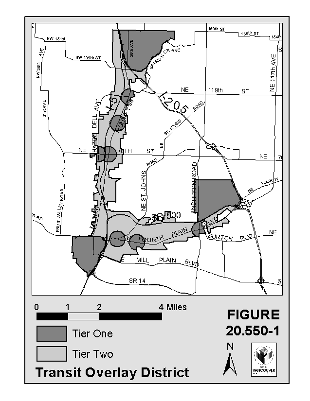
B. Tier 1 Description. Tier 1 shall include the following areas located within the general boundaries of the Transit Overlay District:
1. Urban Centers. Those areas identified as major activity centers on the Clark County and City of Vancouver Comprehensive Land Use Plans commonly known as: Downtown Vancouver, Vancouver Mall and Washington State University.
2. Transit Nodes. Transit nodes are those locations where fixed route transit routes intersect and provide potential transfer points between routes plus a 1/4 mile radius surrounding such intersection. Transit nodes are those intersections at which weekday transit service is or will be at a minimum level of 15 minute peak frequency for at least one of the two streets and at least 30 minute peak period frequency for the other street. Transit nodes shall also be identified in C-TRAN’s annually updated 6-year Transportation Development Plan. Based on these criteria, the following intersections are identified as transit nodes located outside the urban centers:
a. Fourth Plain Boulevard and St. Johns Boulevard
b. Fourth Plain Boulevard and Grand Avenue
c. Fourth Plain Boulevard and Andresen Road
d. Highway 99 and 78th Street
e. Highway 99 and 99th Street
f. Highway 99 and 117th Street
g. Hazel Dell Avenue and 78th Street
If a development is proposed within a transit node, it shall be the responsibility of the applicant, subject to the review and approval of the planning official, to determine whether the site is within 1/4 mile walking distance of the above-defined intersection within the transit node, as measured along established or proposed pedestrian routes, whether or not sidewalks or other pedestrian improvements currently exist. If the site is within this walking distance, development shall be subject to Tier 1 regulations. If the site is not within this walking distance, development of the site shall be subject to Tier 2 regulations.
3. Transit Stations.
a. Transit stations shall be defined as those areas located within a 1/2 mile radius of high capacity transit stations as identified in this chapter. No transit stations have been identified upon the passage of this chapter but will be identified at such time as a locally preferred alternative is adopted pursuant to the Federal Alternatives Analysis Study. Additional transit stations may be identified at a future time. Until such time as the transit stations are identified in this chapter, such areas will remain in Tier 2. Once transit stations are identified in this chapter, such areas may be subject to Tier 1 regulations if the conditions of 20.255.020(B)(3)(b) are met.
b. If a development is proposed within a transit station area, it shall be the responsibility of the applicant, subject to the review and approval of the planning official, to determine whether the site is within a 1/2 mile walking distance to the transit station, as measured along established or proposed pedestrian routes, whether or not sidewalks or other pedestrian improvements currently exist. If a proposed development is within this walking distance, such development shall be subject to Tier 1 regulations. If the site is not within this walking distance, development of the site shall be subject to Tier 2 regulations.
C. Tier 2 Designation. Tier 2 shall be those areas within the general boundaries of the Transit Overlay District that are not identified as Tier 1.
D. Tier 1 Transit Streets.
1. Tier 1 transit streets shall be identified as those streets or segments of streets located within the Vancouver Urban Growth Area, at which weekday transit service is or will be at a minimum level of ten (10) minute peak frequency. In order to be considered by the City of Vancouver as a Tier 1 transit street, said street shall be identified in C-Tran’s annually updated 6-year Transit Development Plan. Development adjacent to such transit streets shall be subject to Tier 1 regulations.
The city and C-Tran shall work cooperatively in designating streets as transit streets through the following process and such other processes as the agencies shall agree: once C-Tran formally, through Board action, lists a street in its 6-year Transit Development Plan which has or will have a minimum level of ten (10) minute peak frequency, the city shall consider amending this chapter to include such street as a transit street subject to the Tier 1 regulations.
E. Tier 2 Transit Streets. (Reserved for future use) (Ord. M-3643, 01/26/2004)