20.740.110 Fish and Wildlife Habitat Conservation Areas.
Click here to view prior versions of this section.
A. Designation.
1. Final designations shall be based on site conditions and other available data or information (See VMC 20.740.020(C)(1)). There are established in the city the following identified Fish and Wildlife Habitat Conservation Areas:
a. Habitat used by any life stage of state or federally designated endangered, threatened, and sensitive fish or wildlife species. A current list of federally and state identified species is available from the planning official.
b. Priority Habitats and areas associated with Priority Species. Current lists of Priority Habitats and Species and applicable Management Recommendations promulgated by the Washington Department of Fish and Wildlife are available from the planning official.
c. Water bodies including lakes, streams, rivers, and naturally occurring ponds.
d. Habitats of Local Importance. Fish and Wildlife Habitat Conservation Areas which are not designated as Priority Habitats and Species by the state but are designated as locally significant by the city in accordance with VMC 20.740.100.
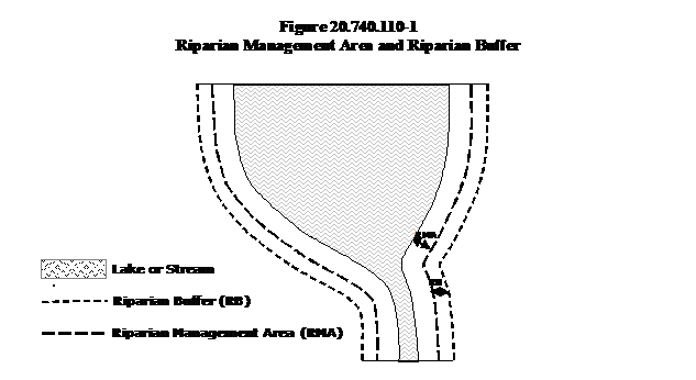
e. Riparian Management Areas and Riparian Buffers. The regulated areas include the land from the ordinary high water mark to a specified distance as measured horizontally in each direction. The Riparian Management Area is adjacent to the lake, stream or river, and the Riparian Buffer is adjacent to the Riparian Management Area.
(1) The Riparian Management Areas and Riparian Buffers are as follows:
|
DNR/Vancouver Stream Type |
Description |
Land Use Intensity1 |
RMA |
RB2 |
|---|---|---|---|---|
|
S |
Shorelines-of-the-State |
High/Moderate/Low |
100’ |
75’ |
|
F |
Lakes, streams, and rivers that contain fish habitat |
High/Moderate/Low |
100’ |
75’ |
|
Np or Ns, large |
Streams and rivers that: (1) are not shorelines-of-the-state; (2) do not contain fish habitat; (3) are wider than 5’ between the ordinary high water marks on the banks. |
High/Moderate/Low |
100’ |
75’ |
|
Np, small, connected |
Streams and rivers that: (1) are not shorelines-of-the-state; (2) do not contain fish habitat; (3) are not more than 5’ wide; (4) do connect via surface water to another stream or river (whether perennial or seasonal) even if the connection traverses a culvert, wetland, or other feature; and (5) are perennial |
High/Moderate Low |
100’ 100’ |
50’ 25’ |
|
Ns, small, connected |
Streams and rivers that: (1) are not shorelines-of-the-state; (2) do not contain fish habitat; (3) are not more than 5’ wide; (4) do connect via surface water to another stream or river (whether perennial or seasonal) even if the connection traverses a culvert, wetland, or other feature; and (5) are seasonal |
High/Moderate Low |
100’ 100’ |
25’ 0’ |
|
Np or Ns, small, not connected |
Streams and rivers that: (1) are not shorelines-of-the-state; (2) do not contain fish habitat; (3) are not more than 5’ wide; (4) do not connect via surface water to another stream or river; and (5) are either perennial or seasonal |
High/Moderate/Low |
25’ |
0’ |
1Refer to Table 20.740.140-1.
2The RB is the distance shown or the full extent of the 100-year floodplain, whichever is farther landward.
(A) When impervious surfaces from previous development completely functionally isolate the Riparian Management Area or the Riparian Buffer from the waterbody, the regulated riparian area shall extend from the ordinary high water mark to the impervious surfaces. If the waterbody is not completely physically isolated, but is completely functionally isolated, the Planning Official may adjust the regulated riparian area to reflect site conditions and sound science.
2. Habitat Location Information. Information on the approximate location and extent of Habitat Conservation Areas is available from the planning official.
The habitat location information is based on:
a. Washington Department of Fish and Wildlife Priority Habitat and Species Maps;
b. Washington Department of Fish and Wildlife Anadromous and Resident Salmonid Distribution Maps in the Salmon and Steelhead Habitat Inventory Assessment Program (SSHIAP);
c. Washington Department of Natural Resources Official Water Type Reference Maps;
d. City-designated Habitats of Local Importance;
e. Other information acquired by the city.
B. Additional Critical Areas Report Requirements.
1. A Critical Areas Report for a Riparian Management Area or Riparian Buffer shall include evaluation of the habitat functions using the Clark County Habitat Conservation Ordinance Riparian Habitat Field Rating Form or another habitat evaluation tool approved by the Washington Department of Fish and Wildlife.
a. In addition to the standards of (VMC 20.740.050(F)), where a mitigation plan is required as part of the Critical Areas Report for a fish and wildlife habitat conservation area that involves a water body, Riparian Management Area or Riparian Buffer, the monitoring program protocol shall include where relevant to the impacted functions:
1. Observations and measurements of riparian integrity and quality (buffer width, riparian corridor continuity or fragmentation, species diversity, stand age, plant survival rates)
2. Large woody debris surveys
3. Streamflow monitoring
4. Water quality monitoring to detect pollution impacts
5. Biological monitoring (including fish surveys and benthic macroinvertebrate sampling)
2. If the clearing or development activity is in the Riparian Management Area, the Critical Areas Report shall contain the following information, if applicable, in addition to the general Critical Areas Report requirements of VMC 20.740.050:
a. How the clearing or development activity constitutes a water-dependent, water-related or water-enjoyment use; or
b. How the clearing or development activity cannot feasibly be located on the site outside of the Riparian Management Area; and
c. How the proposal meets the Riparian Management Area width averaging standard (VMC 20.740.110(C)(2)(c)); and
d. How the proposal will not adversely affect the connectivity of habitat functions.
C. Performance Standards.
1. General.
a. Development or clearing activities shall protect the functions of the Habitat Conservation Areas on the site. The activity shall result in no net loss of functions. Protection can be provided by avoiding (the preferred protection) or minimizing and mitigating as described in the general critical areas approval criteria (VMC 20.740.060). Functions include:
1. Providing habitat for breeding, rearing, foraging, protection and escape, migration, and over-wintering; and
2. Providing complexity of physical structure, supporting biological diversity, regulating stormwater runoff and infiltration, removing pollutants from water, and maintaining appropriate temperatures.
b. An applicant shall replace any lost functions preferably by restoring or if not, then by enhancing other habitat functions, so long as the applicant demonstrates that enhancement of the other functions provides no net loss in overall functions and maintains habitat connectivity. An example of unavoidable loss of function would be interruption of a travel corridor in a Riparian Management Area or Buffer. To the maximum extent feasible, enhancement shall be undertaken on-site.
c. If development or clearing activity is within a Priority Habitat and Species area the applicant shall follow Washington Department of Fish and Wildlife Management Guidelines, Management Recommendations or other standards approved by the Washington Department of Fish and Wildlife. Where there are no guidelines, recommendations or other standards, development or clearing may occur provided that:
1. The development or clearing results in no net loss of habitat function on the site; and
2. Functionally significant habitat, defined as habitat that cannot be replaced or restored within 20 years, shall be preserved.
d. Signs for Fish and Wildlife Conservation Areas
1. Temporary markers. The location of the outer perimeter of the fish and wildlife habitat conservation area shall be marked in the field, and such marking shall be approved by the planning official prior to the commencement of permitted activities. Such field markings shall be maintained throughout the duration of the permit.
2. Permanent signs. Permanent signs shall be posted on public and private properties at an interval of one per lot for single family residential uses or at a maximum interval of 200 feet or as otherwise determined by the planning official, and must be perpetually maintained by the property owner. The sign shall be worded as follows or with alternative language approved by the planning official: “The area beyond this sign is a fish and wildlife habitat conservation area. Alteration or disturbance is prohibited by law. Please call the City of Vancouver for more information.”
2. Riparian Management Areas and Riparian Buffers.
In addition to the standards in VMC 20.740.060 and VMC 20.740.110(C)(1) the standards in this section shall apply in Riparian Management Areas and Buffers.
a. Riparian Buffer. Development or clearing activity may occur in the Riparian Buffer, providing that:
1. The planned mitigation results in no net loss of riparian habitat functions on the site, and
2. Functionally significant habitat, defined as habitat that cannot be replaced or restored within 20 years, shall be preserved unless the activity meets the conditions of VMC 20.740.110(C)(2)(b). An example of habitat that cannot be replaced within 20 years would be a stand of mature trees or a peat bog.
b. Riparian Management Area. No development or clearing activity is allowed within the Riparian Management Area unless such activity is:
1. A water-dependent, water-related or water-enjoyment activity where there are no feasible alternatives that would have a less adverse impact on the Riparian Management Area or Riparian Buffer. The applicant shall minimize the impact and mitigate for any unavoidable impact to functions; Cost may be considered, but shall not be overriding; or
2. A road, railroad, trail, dike, or levee or a water, sewer, stormwater conveyance, gas, power, cable, fiber optic, or telephone facility that cannot feasibly be located outside of the Riparian Management Area, that minimizes impacts, and that mitigates for any unavoidable impact to functions. Cost may be considered, but shall not be overriding; or
3. Mitigation for activities allowed by this chapter, providing the activity provides no net loss of riparian habitat functions on the site.
c. Modification of the Riparian Management Area Width. The width of the Riparian Management Area may be modified (See VMC 20.170.080(B)(1)) if all the following are met:
1. The square footage of the area meeting the performance standards of the Riparian Management Area (VMC 20.740.110(C)(2)(b)) is not reduced; and
2. There is no net loss of functions as a result of the averaging; and
3. Notwithstanding any other provision, the reduction of the Riparian Management Area width at any location may be no greater than 25%.
d. Owners of developed properties within the Riparian Management Area or Riparian Buffer are encouraged to enhance the area by planting native plants and to apply integrated pest management.
e. Agricultural activities in the Riparian Management Area or Riparian Buffer are encouraged to develop farm conservation plans. (Ord. M-3931 § 25, 11/02/2009; Ord. M-3844 § 2, 10/01/2007; M-3692, Added, 02/28/2005, Sec 2)