20.740.120 Frequently Flooded Areas.
Click here to view prior versions of this section.
This section shall apply to all special flood hazard areas within the boundaries of the city of Vancouver.
A. Designation. Frequently flooded areas are the areas of special flood hazards identified by the Federal Insurance Administration and the Federal Emergency Management Agency (FEMA), respectively, in scientific and engineering reports entitled Flood Insurance Study: Clark County, Washington and Incorporated Areas, Volumes 1 and 2 (Numbers 53011CV001A and 53011CV002A, respectively) effective September 5, 2012, and any revisions thereto, with accompanying Flood Insurance Rate Maps (FIRMs and their digital version, DFIRMs) and any revisions thereto, which are hereby adopted by reference and declared to be part of this chapter. The Flood Insurance Study (FIS), FIRMs and DFIRMs are available from the planning official, 415 West 6th Street, Vancouver, WA 98660. (See VMC 20.150.040, Meanings of Specific Words and Terms, for definitions for “areas of special flood hazards,” “floodplain,” “floodway,” and “frequently flooded areas.”)
When base flood elevation (BFE) data has not been provided in frequently flooded areas (Zone A), the planning official shall obtain, review, and reasonably utilize any base flood elevation and floodway data available from a federal, state or other source in order to administer the provisions of this chapter. This best available information for flood hazard area identification shall be the basis for regulation until a new FIRM/DFIRM is issued.
B. Compliance. All development within special flood hazard areas is subject to the terms of this chapter and other applicable regulations.
C. Penalties for Noncompliance. See VMC 20.740.090.
D. Abrogation and Greater Restrictions. This chapter is not intended to repeal, abrogate, or impair any existing easements, covenants, or deed restrictions. However, where this chapter and another ordinance, easement, covenant, or deed restriction conflict or overlap, whichever imposes the more stringent restrictions shall prevail.
E. Interpretation (Not Mandatory). In the interpretation and application of this chapter, all provisions shall be:
1. Considered as minimum requirements;
2. Liberally construed in favor of the governing body; and
3. Deemed neither to limit nor repeal any other powers granted under state statutes.
F. Warning and Disclaimer of Liability. The degree of flood protection required by this chapter is considered reasonable for regulatory purposes and is based on scientific and engineering considerations. Larger floods can and will occur on rare occasions. Flood heights may be increased by manmade or natural causes. This chapter does not imply that land outside the areas of special flood hazards or uses permitted within such areas will be free from flooding or flood damages. This chapter shall not create liability on the part of the city of Vancouver, any officer or employee thereof, or the Federal Insurance Administration for any flood damages that result from reliance on this chapter or any administrative decision lawfully made hereunder.
G. Severability. This chapter and the various parts thereof are hereby declared to be severable. Should any section of this chapter be declared by the courts to be unconstitutional or invalid, such decision shall not affect the validity of the chapter as a whole, or any portion thereof other than the section so declared to be unconstitutional or invalid.
Figure 20.740.120-1. Frequently Flooded Areas/Areas of Special Flood Hazards
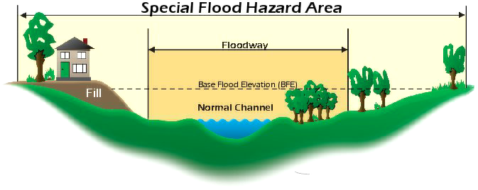
Adapted from Floodplain Management: A Local Administrator’s Guide to the National Flood Insurance Program, Fifth Edition, FEMA Region 10
H. Designation of the Floodplain Administrator (44 CFR 59.22(b)(1)). The land use program manager is hereby appointed to administer, implement, and enforce this chapter by granting or denying development permits in accordance with its provisions. The floodplain administrator may delegate authority to implement these provisions.
1. Duties and Responsibilities of the Floodplain Administrator. Duties of the floodplain administrator shall include, but not be limited to:
a. Permit Review. Review all development permits to determine that:
i. The permit requirements of this chapter have been satisfied;
ii. All other required state and federal permits have been obtained;
iii. The site is reasonably safe from flooding;
iv. The proposed development is not located in the floodway. If located in the floodway, assure the encroachment provisions of Section 5.4-1 are met;
v. Notify FEMA when annexations occur in the special flood hazard area.
I. Additional Critical Areas Report Requirements. In addition to the Critical Areas Report requirements in VMC 20.740.050, the following information shall be submitted. Elevation data shall reference the NAVD 1988 Datum.
1. Base (100-year) flood elevation in relation to mean sea level. When base flood elevation has not been provided or is not available from an authoritative source, it shall be generated by the applicant for developments which contain at least 50 lots or 5 acres, whichever is less.
2. Elevation in relation to mean sea level, of the lowest floor (including basement) of all existing and proposed structures.
3. Elevation in relation to mean sea level to which any structure’s lowest floor (including basement) is raised to be at least 1 foot above the base flood elevation or for nonresidential flood-proofed structures, the elevation in relation to mean sea level to which any structure is flood-proofed.
4. Location of the channel migration zone. See the Clark County Shoreline Inventory & Characterization Report, Volume 1, Lewis and Salmon-Washougal Watersheds and Rural Areas, Map 27, Potential Channel Migration Zone (CMZ) Areas for general locations of channel migration zones. The actual location of the channel migration zone on site must be identified by a qualified professional and mapped in accordance with the submittal requirements of VMC 20.740.050.
5. Description of strategies taken to avoid, minimize, and mitigate unavoidable impacts to public safety. When the base flood elevation has not been provided or is not available from an authorized source (VMC 20.740.120(A)), the Critical Areas Report shall include a discussion of how and whether the proposed development would be reasonably safe from flooding. Historical data, high water marks, photographs of past flooding and other available information will be used as the basis for this discussion and conclusion.
6. Certification, documentation, and demonstration by a qualified professional of how the applicable standards of VMC 20.740.120(J) will be met. To support the “no rise” analyses required in VMC 20.740.120(J)(1), the documentation required in the most recently updated or amended FEMA Region 10 publication, Floodplain Management: A Local Floodplain Administrator’s Guide to the National Flood Insurance Program shall be submitted.
J. Performance Standards. Except as noted, the following standards apply to all structures and development (including but not limited to the placement of manufactured homes, substantial improvement, roads, railroads, trails, dikes, levees, or water, sewer, stormwater conveyance, gas, power, cable, fiber optic or telephone facilities) in all areas of special flood hazards and channel migration zones (CMZs). Additional restrictions apply in the floodway.
1. Encroachments.
a. Designated Floodway: Prohibited Encroachments. The following are prohibited in the floodway:
1. Water wells (20.740.120(J)(4)(a)).
2. On-site waste disposal systems (20.740.120(J)(5)(a)).
3. Residential structures or other structures for human habitation including but not limited to:
a. Building envelopes within subdivisions (20.740.120(J)(9)(a));
b. New construction or reconstruction of residential structures (20.740.120(J)(10)(b)(1));
c. Placement or replacement of manufactured homes (all types) (20.740.120(J)(10)(b)(2));
d. Critical facilities housing vulnerable populations and emergency services (20.740.120(J)(12)(a)); and
e. Recreational vehicles (20.740.120(J)(13)(a)).
b. Designated Floodway: Allowed Encroachments. In areas where the base flood elevation has been provided and a regulatory floodway has been designated, other encroachments including but not limited to fill, new construction, replacement structures, substantial improvements and other development shall be prohibited unless:
1. Certification by a qualified professional (in this case, a registered professional engineer) is provided demonstrating through hydrologic and hydraulic analyses performed in accordance with standard engineering practice that the proposed encroachment would not result in a net increase in base flood elevation (less than 0.00 feet, rounded) or flood velocity during the occurrence of the base flood discharge. At a minimum, such “no rise” analyses shall include a step-backwater analysis and a conveyance compensation analysis as required in the most recently updated or amended FEMA Region 10 publication, Floodplain Management: A Local Floodplain Administrator’s Guide to the National Flood Insurance Program; and
2. The applicable standards of VMC 20.740.120(J)(2) through (J)(15) are also met.
c. No Designated Floodway: Allowed Encroachments. In areas where the base flood elevation has been provided but a regulatory floodway has not been designated, no encroachments including but not limited to new construction, substantial improvement, or other development (including fill) shall be permitted, unless:
1. The applicant has demonstrated that the cumulative effect of the proposed development, when combined with all other existing and anticipated development will not increase the water surface elevation of the base flood more than one foot at any point; and
2. The applicable standards of VMC 20.740.120(J)(2) through (J)(15) are also met.
d. Other Areas of Special Flood Hazards and CMZs. In areas of special flood hazards except the floodway or where the BFE has not been provided, or in channel migration zones, encroachments, including but not limited to fill, new construction, replacement structures, substantial improvements and other development shall be prohibited, unless:
1. A qualified professional provides certification demonstrating that the proposed project would not result in a net loss of flood storage capacity; and
2. The applicable standards of VMC 20.740.120(J)(2) through (J)(15) are also met.
2. Property Damage. Development shall not result in adverse impacts to other properties either upstream or downstream.
3. Drainage. Drainage paths around structures and on slopes shall be adequate to guide floodwaters around and away from proposed structures and adjacent properties.
4. Water.
a. Water wells are prohibited in the floodway.
b. In areas of special flood hazards except the floodway and in CMZs, water wells shall be constructed to withstand a 100-year flood without adversely impacting groundwater quality (WAC 173-160-171).
c. All new and replacement water supply systems shall be designed to minimize or eliminate infiltration of flood waters into the system.
5. Waste.
a. On-site waste disposal systems are prohibited in the floodway.
b. In areas of special flood hazards except the floodway and in CMZs, on-site waste disposal systems shall be located to avoid flood damage to them or release of contaminants from them during a base flood event.
c. New and replacement sanitary sewage systems shall be designed to minimize or eliminate infiltration of flood waters into the systems and discharge from the systems into flood waters.
6. Construction Materials and Methods.
a. Construction methods and practices shall minimize flood damage.
b. Construction materials and utility equipment shall be resistant to flood damage. For guidance on flood-resistant materials see the most current FEMA Technical Bulletin 2, Flood-Resistant Materials Requirements.
c. Electrical, heating, ventilation, plumbing, and air conditioning equipment and other service facilities shall be designed and/or otherwise elevated or located so as to prevent water from entering or accumulating within the components during a base flood event. For guidance on the placement of building utility systems, see the most current FEMA Publication #348, Protecting Building Utilities from Flood Damage.
7. Anchoring. All new construction including substantial improvements and all types of manufactured homes shall:
a. Be elevated on a permanent foundation and securely anchored to an adequate foundation system to prevent flotation, collapse, or lateral movement of the structure resulting from hydrodynamic and hydrostatic loads including the effects of buoyancy.
b. Be installed or placed using methods and practices that minimize flood damage. Manufactured home placement shall follow the guidance in the most current FEMA P-85, Protecting Manufactured Homes from Floods and Other Hazards.
8. Enclosed Areas Below the Base Flood Elevation.
a. Enclosed areas below the base flood elevation shall be used only for vehicle parking, building access, or storage.
b. New or substantially improved enclosed areas below the base flood elevation shall be constructed in accordance with.
1. VMC 20.740.120(J)(7), Anchoring
2. VMC 20.740.120(J)(10)(c)(2)(d), Residential Construction
3. VMC 20.740.120(J)(6)(b) and (J)(6)(c), Construction Materials and Methods
c. Enclosed areas below the BFE shall not be considered to be the lowest floor when they are not part of a basement and meet the requirements of VMC 20.740.120(J)(10)(d).
d. Crawlspace Construction. Crawlspaces are a type of enclosed area below the BFE. Crawlspaces constructed at or above the lowest adjacent exterior grade are preferred. (Note: Insurance premiums for structures with below-grade crawlspaces will be higher than those with the interior elevation at or above the lowest adjacent exterior grade.) Refer to the most current FEMA Technical Bulletin 11, Crawlspace Construction for Buildings Located in Special Flood Hazard Areas (available from the Planning Official) for more information. Crawlspaces:
1. Are prohibited in areas with flood velocities greater than five feet (5’) per second unless designed by a qualified professional (in this case an architect or professional engineer).
2. Shall meet the requirements of VMC 20.740.120(J)(8)(a) through (J)(8)(c), Enclosed Areas below the BFE.
3. Shall not be considered “basements” for the purposes of VMC 20.740.120 when constructed according to the following standards:
a. The interior grade of a crawlspace below the base flood elevation must not be more than 2’ below the lowest adjacent exterior grade.
b. The height of the below-grade crawlspace, measured from the interior grade of the crawlspace to the top of the crawlspace foundation wall must not exceed 4’ at any point.
c. The crawlspace must be equipped with a drainage system that removes floodwaters from the interior area of the crawlspace in a reasonable period of time after a base flood event.
9. Subdivisions.
a. All subdivisions shall be designed:
1. To ensure that no residential structure or other structures for human habitation are located in the floodway even though lots may extend into the floodway;
2. To avoid placement of any structures in areas of special flood hazards and in CMZs;
3. Where it is not possible to design a subdivision in a manner to avoid placement of any structures in areas of special flood hazards or CMZs, the subdivision shall be designed to minimize or eliminate potential flood damage.
b. All subdivisions shall have facilities such as sewer, gas, power, cable, fiber optic, telephone, stormwater and water systems located and constructed to minimize or eliminate flood damage. (See VMC 20.740.120(J)(2), Property Damage; VMC 20.740.120(J)(4), Water; VMC 20.740.120(J)(5), Waste; VMC 20.740.120(J)(6), Construction Materials and Methods; and VMC 20.740.120(J)(7), Anchoring.)
c. All subdivisions shall have adequate drainage provided to reduce exposure to flood damage. (See VMC 20.740.120(J)(3), Drainage.)
10. Residential Construction (Including Manufactured Homes).
a. Residential Construction in the Floodway.
1. New construction and reconstruction of residential development including placement and replacement of all types of manufactured homes is prohibited in the floodway.
2. Existing residential structures and manufactured homes in the floodway are nonconforming, but may be repaired or improved, provided:
a. The repair or improvement does not increase the ground floor area of the structure; and
b. The repair or improvement does not result in adverse impacts to other properties either upstream or downstream; and
c. The cost of the repair or improvement does not exceed 50% of the market value of the structure either:
1. Before the start of repair or improvement where there is no damage to the structure; or
2. Before flood or other damage to the structure occurred.
d. Any project for improvement of a structure to correct existing violations of state of local health, sanitary, or safety code specifications which have been identified by the Planning Official and which are the minimum necessary to assure safe living conditions may be excluded from the 50%.
e. Any project for improvement to a structure identified as a historic place may be excluded from the 50%.
b. Residential Construction in Other Areas of Special Flood Hazards and CMZs. In areas of special flood hazards except the floodway and in channel migration zones:
1. New residential construction and reconstruction, including all types of manufactured homes and other structures for human habitation shall meet all the provisions of this chapter, including VMC 20.740.120(J)(8) and (J)(10)(c) through (J)(10)(d).
2. New placement or replacement of all types of manufactured homes shall meet the standards of VMC 20.740.120(J)(7), Anchoring.
3. Repair or Substantial Improvement. All provisions of this chapter (including the elevation standards of VMC 20.740.120(J)(8) and (J)(10)(c) and (J)(10)(d)), all state and local health, sanitary, safety codes, and where applicable, historic preservation codes shall be met when the cost of repair or improvement of an existing residential structure exceeds 50% of the market value of the structure either:
a. Before the start of repair or improvement where there is no damage to the structure; or
b. Before flood or other damage to the structure occurred.
c. Elevation.
1. BFE Established. The lowest floor (including basement) of new residential structures (including but not limited to reconstruction, substantial improvement, the placement or replacement of all types of manufactured homes) shall be elevated at least one foot above base flood elevation. Structures shall be elevated using means other than fill (such as extended foundation or other enclosure walls, piles, or columns) whenever feasible. Mechanical equipment and utilities shall be waterproofed or elevated at least one foot above the BFE.
2. No BFE. In areas where the base flood elevation has not been provided or is not available from an authorized source (VMC 20.740.120(A) and (I)(5)) and the Critical Areas Report demonstrates to the satisfaction of the Planning Official that the proposed development would be reasonably safe from flooding, new residential construction (including but not limited to substantial improvement and the placement of manufactured homes) shall be elevated at least 2’ above the highest adjacent grade. (Note: Failure to elevate at least 2’ above the highest adjacent grade may result in higher insurance rates.)
d. Fully Enclosed Areas Below Lowest Floor. Fully enclosed areas below the lowest floor that are subject to flooding are prohibited unless designed to automatically equalize hydrostatic flood forces on exterior walls by allowing for the entry and exit of floodwaters. Designs for meeting this requirement must be certified by a qualified professional (in this case, a registered professional engineer or architect), or must meet or exceed the following minimum criteria:
1. Contain a minimum of 2 openings having a total net area of not less than 1 square inch for every 1 square foot of enclosed area subject to flooding;
2. The bottom of all openings are no higher than 1 foot above grade; and
3. Openings permit the automatic entry and exit of floodwaters even when equipped with screens, louvers, or other coverings or devices.
For guidance on flood openings, see FEMA Technical Bulletin 1-93, Openings in Foundation Walls.
4. A garage attached to a residential structure, constructed with the garage floor slab below the BFE, must be designed to allow for automatic entry and exit of floodwaters.
11. Nonresidential Construction. New construction and substantial improvement of any nonresidential structure shall either be elevated (subsection (J)(11)(a) or (J)(11)(b) of this section) or flood-proofed (subsection (J)(11)(c) of this section):
a. Be Elevated: BFE Established.
1. Have the lowest floor, including basement, elevated at least one foot above the base flood elevation or elevated as required by ASCE 24, whichever is greater;
2. Meet the same standards for space below the lowest floor as described in subsections (J)(8)(d) and (J)(10)(d)(1) through (J)(10)(d)(3) of this section; and
3. Have mechanical equipment and utilities waterproofed or elevated at least one foot above the BFE, or as required by ASCE 24, whichever is greater.
b. Be Elevated: No BFE.
1. In areas where the base flood elevation has not been provided or is not available from an authorized source (VMC 20.740.120(J)(2A) and (3.120(B)(5)) and the Critical Areas Report demonstrates to the satisfaction of the Planning Official that the proposed development would be reasonably safe from flooding, new nonresidential construction shall be elevated at least 2’ above the highest adjacent grade. Failure to elevate at least 2’ above the highest adjacent grade may result in higher insurance rates; and
2. Meet the same standards for space below the lowest floor as described in 20.740.120(J)(8)(d) and VMC 20.740.120(J)(10)(d); or
c. Be Flood-Proofed. Together with attendant utility and sanitary facilities shall:
1. Be flood-proofed so that below one foot (or more) above the base flood elevation, the structure is watertight with walls substantially impermeable to the passage of water or dry flood-proofed to the elevation required by ASCE 24, whichever is greater;
2. Have structural components capable of resisting hydrostatic and hydrodynamic loads and effects of buoyancy;
3. Be certified by a registered professional engineer or architect that the design and methods of construction are in accordance with accepted standards of practice for meeting provisions of this subsection based on their development and/or review of the structural design, specifications and plans. Such certifications shall be provided to the Planning Official as set forth in VMC 20.740.120(L).
12. Critical Facilities.
a. Critical facilities housing vulnerable populations and emergency services shall be prohibited in the floodway.
b. In areas of special flood hazards except the floodway and in CMZs, construction of new critical facilities shall be prohibited unless the applicant demonstrates that:
1. No feasible alternative site is available; and either:
a. The lowest floor, entrances, egresses, and to the extent feasible access routes are elevated to three feet above the base flood elevation or to the elevation of the 500-year flood, whichever is higher; or
b. The applicant demonstrates that other measures would ensure that in the event of a flood, the facility would remain safe and fully operational and that potentially harmful materials would not be displaced by or released into floodwaters. Such measures shall be conditions of approval of the Critical Areas Permit.
13. Recreational Vehicles.
a. Recreational vehicles shall be located outside the floodway.
b. Recreational vehicles in areas of special flood hazard except the floodway and in CMZs shall either:
1. Be on the site for fewer than 180 consecutive days;
2. Be fully licensed and ready for highway use, on its wheels or jacking system, attached to the site only by quick disconnect-type water, sewer, stormwater, gas, power, cable, fiber optic, telephone, and security devices, and have no permanently attached additions; or
3. Meet the requirements of VMC 20.740.120(J)(7), Anchoring; VMC 20.740.120(J)(8), Enclosed Areas below the Base Flood Elevation; and VMC 20.740.120(J)(10)(c), Elevation.
14. Appurtenant Structures (Detached Garages and Small Storage Structures). For A zones:
a. Appurtenant structures used solely for parking of vehicles or limited storage may be constructed such that the floor is below the BFE, provided the structure is designed and constructed in accordance with the following requirements:
i. Use of the appurtenant structure must be limited to parking of vehicles or limited storage;
ii. The portions of the appurtenant structure located below the BFE must be built using flood-resistant materials;
iii. The appurtenant structure must be adequately anchored to prevent flotation, collapse, and lateral movement;
iv. Any machinery or equipment servicing the appurtenant structure must be elevated or flood-proofed to or above the BFE;
v. The appurtenant structure must comply with floodway encroachment provisions in Section 5.4-1;
vi. The appurtenant structure must be designed to allow for the automatic entry and exit of floodwaters in accordance with Section 5.2-1(5);
vii. The structure shall have low damage potential;
viii. If the structure is converted to another use, it must be brought into full compliance with the standards governing such use; and
ix. The structure shall not be used for human habitation.
b. Detached garages, storage structures, and other appurtenant structures not meeting the above standards must be constructed in accordance with all applicable standards in Section 5.2-1.
c. Upon completion of the structure, certification that the requirements of this section have been satisfied shall be provided to the floodplain administrator for verification.
15. Alteration of Watercourse.
a. The planning official shall notify adjacent communities and the state coordinating agency, Washington State Department of Ecology, prior to any alteration or relocation of a watercourse, and submit evidence of such notification to the Federal Insurance Administration.
b. Alteration or relocation of a watercourse shall be allowed only after:
i. Certification by a qualified professional that the alteration or relocation:
A. Is the only feasible alternative or is part of a restoration project approved by the appropriate state or federal agencies;
B. Will not diminish the flood-carrying capacity of the watercourse;
C. Will not block side channels;
D. Will be accomplished using soft armoring techniques wherever possible;
E. Will avoid to the extent possible and then minimize and mitigate removal of vegetation including downed woody vegetation; and
F. Will not endanger development in the channel migration zone.
ii. The applicant provides assurance acceptable to the planning official of maintenance of the relocated channel such that the flood carrying capacity of the watercourse is not diminished.
16. Changes to Special Flood Hazard Area.
a. If a project will alter the BFE or boundaries of the SFHA, then the project proponent shall provide the community with engineering documentation and analysis regarding the proposed change. If the change to the BFE or boundaries of the SFHA would normally require a letter of map change, then the project proponent shall initiate within 180 days of the information being made available, and receive approval of, a conditional letter of map revision (CLOMR) prior to approval of the development permit. The project shall be constructed in a manner consistent with the approved CLOMR.
b. If a CLOMR application is made, then the project proponent shall also supply the full CLOMR documentation package to the floodplain administrator to be attached to the floodplain development permit, including all required property owner notifications.
K. Variances and Minor Exceptions. Variances as interpreted in the National Flood Insurance Program are based on the principle that they pertain to a physical piece of property. They apply to the land and are not personal in nature, do not pertain to the structure, its inhabitants, or economic or financial circumstances. The development standards contained in VMC 20.740.120, Frequently Flooded Areas are required by the Federal Emergency Management Agency (FEMA) under the National Flood Insurance Program (NFIP) to protect life and property from flood damage.
Variances from the NFIP standards of VMC 20.740.120 shall meet the approval criteria and other requirements of VMC 20.740.120(K) in addition to any other applicable variance criteria or requirements (e.g., VMC 20.290 or VMC 20.760). Variances from the NFIP standards of VMC 20.740.120 shall be processed as Type I or II variances or shoreline variances as appropriate, not as Minor Exceptions (VMC 20.740.070).
Variances or minor exceptions from other critical area standards (any standards of VMC 20.740 not in Section VMC 20.740.120) shall meet the applicable criteria and follow the applicable procedures for the relief requested (VMC 20.740.070, VMC 20.290, or VMC 20.760)
1. NFIP variances may be allowed:
a. For Historic Structures. NFIP variances may be issued for the repair, reconstruction, rehabilitation or restoration of structures listed on the National Register of Historic Places, the Washington Heritage Register, Washington’s Heritage Barn Register, Washington’s Historic Property Inventory Database, Clark County Cultural Resources Inventory, or Clark County Heritage Register, provided:
1. The proposed development will not preclude the structure’s continued designation as a historic structure;
2. The variance is the minimum necessary to preserve the historic character and design of the structure; and
3. NFIP variance approval criteria at (VMC 20.740.120(K)(2)(a) through (K)(2)(d) are met.
b. From the Elevation Standard. An NFIP variance from the elevation standard may be issued for new construction and substantial improvements to be erected on a small or irregularly shaped lot contiguous to and surrounded by lots with existing structures constructed below the base flood elevation. As the lot size increases the technical justification required for issuing the variance increases.
c. From the Flood-proofing Standard for Non-Residential Buildings. NFIP variances may be issued for nonresidential buildings to allow a lesser degree of flood-proofing than watertight or dry flood-proofing where it can be determined that such action:
1. Will have low damage potential;
2. Complies with all other NFIP variance criteria except VMC 20.740.120(K)(1)(a)(2);
3. Complies with VMC 20.740.120(J)(4), Water; VMC 20.740.120(J)(5), Waste; VMC 20.740.120(J)(7), Anchoring; and VMC 20.740.120(J)(9), Subdivisions.
d. For Allowed Development within the Floodway. NFIP variances may be issued for development within a floodway only when the requirements of VMC 20.740.120(J)(1)(b) are met.
2. NFIP Variance Approval Criteria. NFIP variances from elevation and flood-proofing standards, and for development in the floodway (VMC 20.740.120(K)(1)(a)(2) through (4) may be granted only if the applicant demonstrates that the requested action conforms to all of the following criteria:
a. The NFIP variance is the minimum necessary, considering the flood hazard, to afford relief.
b. The applicant has demonstrated good and sufficient cause.
c. Failure to grant the NFIP variance would result in exceptional hardship to the applicant. (Exceptional hardship for an NFIP variance is described in a FEMA memorandum dated July 22, 1986 entitled Resource Materials on NFIP Variance Criteria available from the Planning Official.)
d. Granting the NFIP variance will not result in increased flood heights or velocities, additional threats to public safety, significantly increased property damage potential, extraordinary public expense, or conflict with existing local laws or ordinances.
e. Demonstration that the following factors have been considered:
1. The danger that materials may be swept onto other lands to the injury of others;
2. The danger to life and property due to flooding or erosion damage;
3. The susceptibility of the proposed facility and its contents to flood damage and the effect of such damage on the individual owner;
4. The importance of the services provided by the proposed facility to the community;
5. The necessity to the facility of a waterfront location, where applicable;
6. The availability of alternative locations for the proposed use which are not subject to flooding or erosion damage;
7. The compatibility of the proposed use with existing and anticipated development;
8. The relationship of the proposed use to the comprehensive plan;
9. The safety of access to the property in times of flood for ordinary and emergency vehicles;
10. The expected heights, velocity, duration, rate of rise, and sediment transport of the flood waters and the effects of wave action, if applicable, expected at the site; and
11. The costs of providing governmental services during and after flood conditions, including maintenance and repair of facilities such as sewer, gas, electrical, stormwater, and water systems, and streets and bridges.
3. Notices Required. A notice to the applicant is required whenever a variance is approved, approved with conditions, or denied. Such notice shall include the decision and the reasons for the decision. When a variance from the elevation standard is approved or approved with conditions, such notice shall state that the structure will be permitted to be built with a lowest floor elevation below that normally required with respect to the base flood elevation and that the cost of flood insurance will be commensurate with the increased risk resulting from the reduced lowest floor elevation.
L. Information to be Obtained and Maintained.
1. For all new and substantially improved structures and development, the planning official shall complete Section B of a current elevation certificate and obtain and record on that certificate:
a. For elevated (rather than flood-proofed) structures and development, the actual (as-built) elevation in relation to mean sea level of the lowest floor (including basement), and whether or not the structure contains a basement.
b. For nonresidential, flood-proofed structures, the elevation to which the structure was flood-proofed. All flood-proofing certifications shall also be maintained.
c. Maintain all records pertaining to development in frequently flooded areas subject to the provisions of this chapter, VMC 20.740, for public inspection.
2. Records of Variance Actions. The planning official shall keep records of all variance actions and report any approved variances to the Federal Insurance Administration upon request.
3. Records of Appeal Actions. The planning official shall keep records of all appeal actions. (Ord. M-4325 § 3, 2020; Ord. M-4020 § 2, 2012; Ord. M-4017 § 9, 2012; Ord. M-3844 § 2, 2007; Ord. M-3692 § 2, 2005)